The October 2025 Flood
Five inches of rain over one long week in October 2025. Nobody died. About ninety homes were damaged, two taken outright, and the neighbors are still answering.
The week #
It did not arrive all at once. It built over days, then turned on a Saturday.
- Wednesday, Oct 8
La Plata County opens a sandbag release, getting material into the valley ahead of the forecast.
- Thursday, Oct 9
The National Weather Service posts a flood watch for the Four Corners.
- Friday, Oct 10
The rain settles in and stays. That evening, Grand Junction's weather balloon measures 1.05 inches of precipitable water in the column overhead — the most ever recorded there that late in the year.
- Saturday, Oct 11 — the day
It turned on a Saturday, hour by hour.
- 12 a.m.
Vallecito Creek runs about 1,000 cubic feet per second, just after midnight — already high, and still climbing.
- Dawn
Chief Bruce Evans of the Upper Pine River Fire Protection District wakes to the gauge alarms and starts the calls. Within hours about 400 homes are flagged for evacuation; the final count is 390.
- Morning
CodeRED evacuation alerts go out through the La Plata County Sheriff's Office.
- ~11 a.m.
A levee gives way on the west side of Vallecito Creek and along Grimes Creek.
- Afternoon
A second breach on the east side floods Tucker Lane. Crews make eleven high-water rescues, most of them here.
- 1:45 p.m.
The creek peaks at about 7,000 cubic feet per second — 7,220 on the USGS gauge, 6,980 in the Weather Service’s crest record. La Plata County declares its first-ever flood disaster.
- Evening
The Red Cross opens a shelter at Bayfield High School, where about 57 people check in.
- 12 a.m.
- Sunday, Oct 12
A merciful break in the weather. The governor issues a verbal emergency declaration.
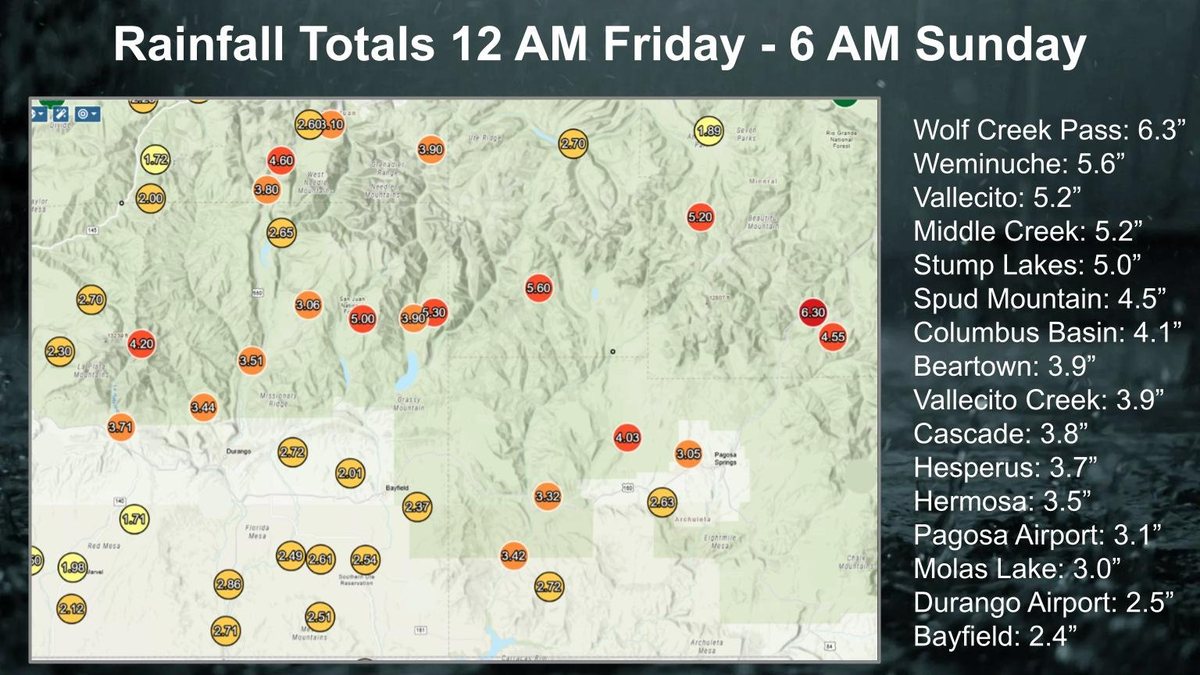
The Weather Service's storm-total map, posted Sunday afternoon, Oct. 12: 5.2 inches at Vallecito in two and a half days. Wolf Creek Pass, at the top of the watershed, caught 6.3.National Weather Service Grand Junction - Monday–Tuesday, Oct 13–14
The remnants of Tropical Storm Raymond move through and the creek crests a second time, around 3,100 to 3,200 cubic feet per second.
- Wednesday, Oct 15
Safety and damage assessments move through the evacuated area, home by home.
- Thursday, Oct 16 — 8 a.m.
All 390 homes are cleared to return. Residents pick up re-entry tags and Red Cross cleanup kits at the Vallecito Community and Event Center and Vallecito Baptist Church.
The hydrograph #
One gauge tells the day plainly: USGS 09352900, Vallecito Creek near Bayfield. It sat near 80 cubic feet per second before the storm. It touched 7,220, by USGS’s still-provisional count.
Locals call anything over 3,000 cfs high water. Discharge: USGS, provisional pending final review after the water year closes September 30, 2026.
The rain behind it
The creek didn't rise on its own — the Vallecito SNOTEL station measured it falling, day by day.
Daily precipitation at the Vallecito SNOTEL (NRCS). Oct 10–11 alone set a two-day station record; the second, smaller pulse on Oct 13 was Tropical Storm Raymond arriving right behind the first storm.
Typically the water gauges on Vallecito Creek, high water is under 3,000 cubic feet per second. This morning it was at 6,800. Sarah Jacobson, incident public information officer, mid-morning Oct 11 — hours before the afternoon peak, via The Colorado Sun
The dam held #
Vallecito Dam was built in 1941 for exactly this. On the morning of October 11 the reservoir was still near its post-season low — a little over 30,000 acre-feet, under a quarter of capacity — which left roughly 95,000 acre-feet of empty room against the operating pool the dam is held to, and closer to 100,000 against nominal capacity.
Over three days it took the flood in through the intakes alone. Storage climbed from just over 30,000 acre-feet toward almost 56,000 by Tuesday morning — the water had “risen by 15 feet or more,” said Mike Canterbury, the district's dam tender. The emergency spillway could not help: it has been kept out of service since voids were found beneath it after a 2017 dye test. PRID superintendent Ken Beck watched the intakes for floating debris while the water rose.
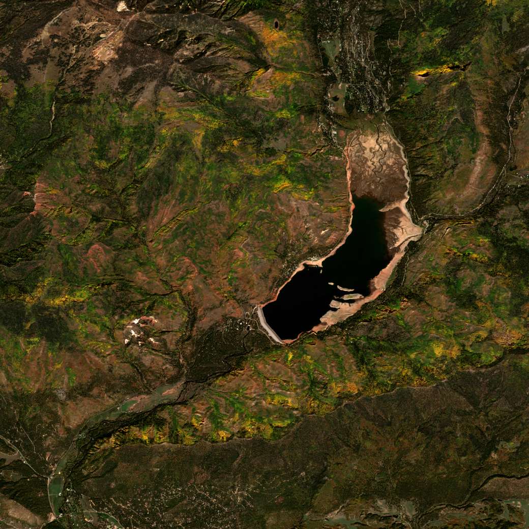
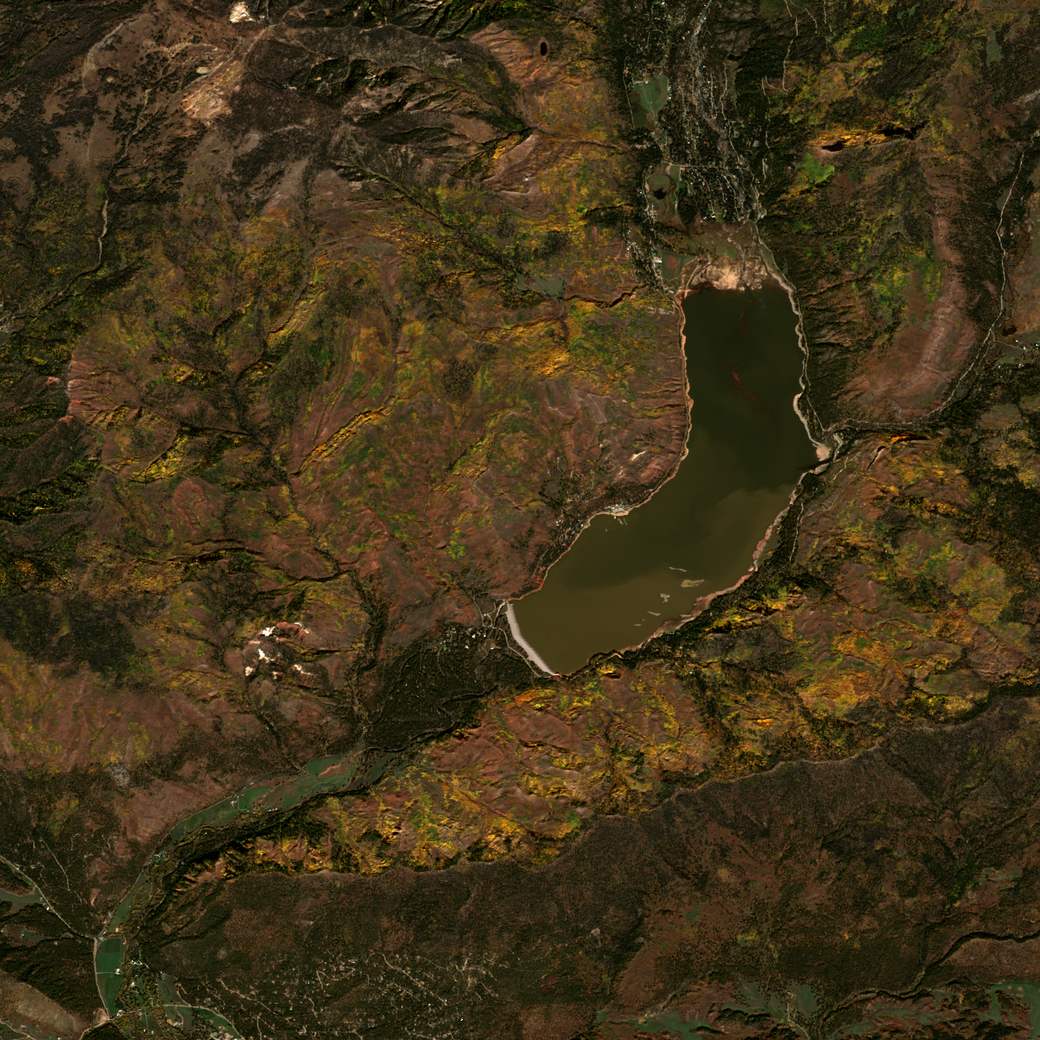
October 2025 storage: 28,600 88,900 acre-feet. Data: Bureau of Reclamation.
The reservoir came up 25 feet in a matter of hours. Ken Beck, superintendent, Pine River Irrigation District, via The Colorado Sun
The two men were reading the same gauge at different moments in the same week: Canterbury's fifteen feet was the rise as of Tuesday morning, with the water still coming up; Beck spoke afterward, of the whole surge. By October 31 the reservoir held about 88,900 acre-feet — roughly three times what it started the month with.
Flood control is the reason this dam exists. It did the one thing it was built to do. The reservoir spared the valley below it. It could do nothing for the homes along the creeks above.
Two sibling stories: the dam's whole 85-year record of rise and fall on Lake Levels & History, and the fire that came before the water on the Missionary Ridge Fire.
In their words #
Water was getting into my boots. I'm in water halfway up to my knee. I'm now starting to realize that this is much more than I've seen in the river before. Barney Miller, Vallecito homeowner, via The Colorado Sun
Running hard and fast, with a lot of debris coming down. Christy Korinko, describing Vallecito Creek. She and her husband Joe, who have owned their home in a 100-year flood plain since 2002, said they'd never seen flooding like this — via Durango Herald
It's like ground zero. Jim Patton, Vallecito property owner, via The Colorado Sun
What the water took #
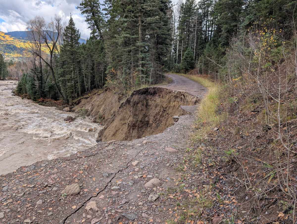
The tally came in slowly, the way these things do. About 90 homes were damaged; two were taken entirely. More than 60 miles of roads, culverts, and drainage were torn up. Five and a half miles up the Vallecito Creek Trail, the Middle Bridge washed away whole; wilderness bridges were lost on two more trails. Wells were fouled. Propane tanks floated off their stands. The campground closed for the season, into spring.

The damage here came to more than $7.5 million. Across the three affected counties — La Plata, Archuleta, and Mineral — the validated total reached $13,820,036.
That was their back yard out in the middle of the river. Wilson Hagg, fleet manager, Upper Pine River Fire Protection District, on a home left with its foundation exposed above the creek, via The Colorado Sun
- 390homes evacuated
- 11high-water rescues
- 57sheltered at Bayfield High
- ~90 / 2homes damaged / lost
- 60+miles of road & drainage
- $7.5Mdamage here
- $13,820,036validated, three counties
- 7,220cfs USGS provisional · NWS 6,980 · record 7,050 (1970)
- 135 / ~40responders / agencies
- 28,600 88,900acre-feet stored, October
No deaths or major injuries were reported.
That sentence was not luck.
Eleven rescues #
Chief Bruce Evans woke to the gauge alarms early and started the calls. CodeRED alerts went out through the Sheriff's Office. Through the morning, firefighters from the Upper Pine River Fire Protection District and deputies from the La Plata County Sheriff's Office made eleven high-water rescues. Firefighters went house to house shutting off propane tanks that had floated loose. A county emergency-management office that normally runs on two people scaled, inside a week, to more than 135 responders drawn from about 40 agencies — led by Shawna Legarza, then the county's emergency management director, who had first come to this valley fighting the 2002 fire.
Neighbors #
What a small place has, when the water comes, is each other.
Bayfield residents packed sandbags by the pallet. Churches ran firewood up the valley as the nights turned cold. Samaritan's Purse crews cleared debris — truckload after truckload at flooded properties. The Community Foundation serving Southwest Colorado opened a relief fund and pledged a match against what neighbors gave. Staff from 2-1-1 sat down in person at the Vallecito Lake Event Center to answer questions face to face. On November 5, the valley gathered for a community recovery meeting at the Weminuche Woodfire Grill. Re-entry kits waited at the Community Center and Vallecito Baptist Church.
Brandon Faulkenburg, a part-time resident who lives in Boulder, spent days after the flood digging trenches and diverting water around a neighbor's home across the street — a home that wasn't his. “Our neighbors are people we can depend on for anything,” he said.
A hot tub, torn loose from its deck when the creek changed course, floated the length of Vallecito Creek — past trees, debris, and bridge after bridge — and drifted into the reservoir still upright, an American flag attached. The community named it the S.S. Tubbie and tracked its progress for nearly a week before Explore Vallecito volunteers retrieved it by boat. “We enjoyed keeping everyone informed of the status of the hot tub,” one volunteer told the Durango Herald. “It was a moment of levity in a bad situation for the community.”
None of it was for sale. It was just what people did.
The long road #
Recovery has been assembled piece by piece, from whatever sources could be found.
The state put in $6 million under Executive Order D 2025 021. La Plata County stood up a Disaster Rebuild Program — waiving fees, with qualification applications open through December 31, 2026, building permits due by December 31, 2028, and construction to be complete by December 31, 2029. The Natural Resources Conservation Service signed an Emergency Watershed Protection agreement on December 19, 2025, with the Upper Pine district as sponsor, splitting costs 75 percent federal, 12.5 percent state, and 12.5 percent landowners. One gap has no clean fix: county funds legally cannot repair private roads, and much of what washed out is private.
The sums add up in uneven pieces. The county reassigned about $1 million of public-works funds to rebuild a single mile of flood-damaged road, La Plata County commissioner Matt Salka told KOAA in June. Statewide, Colorado's cumulative disaster spending has reached $57.5 million since July 2024.
The federal record #
Colorado requested a federal major-disaster declaration on November 12, 2025, citing the validated damage. FEMA denied the request on December 20, 2025. The denial letter's operative finding was a single sentence: “Based on our review of all of the information available, it has been determined that supplemental federal assistance under the Stafford Act is not warranted.” The letter gave no further reason. The state appealed in January; FEMA denied the appeal in April 2026, reaffirming that determination, and the governor's office says no further appeal is available.
On April 29, 2026, Colorado's U.S. senators Michael Bennet and John Hickenlooper introduced S. 4433, the Disaster Declaration Transparency Act — a bill that would require FEMA to put its reasoning in writing within 24 hours when it denies a disaster request, and would give Congress a fast-track path to override a denial. It awaits committee action.
Separately, a Federal Highway Administration emergency award is repairing San Juan National Forest roads through 2027. The recovery is running on state, county, and private funds.
Where it stands #
By July 2026 the campground has reopened for the season, and the county has declared its bridges sound. The feared spring runoff never came — the creek's 2026 peak was a quiet 503 cfs after a thin snowpack (provisional NWPS figure, May 15, 2026). The wilderness bridges are still waiting — not before 2027. And families are still rebuilding.
The recovery's shape has firmed up over the winter and spring. The special improvement district floated early on was abandoned — Upper Pine's board found, after legal review, that not every parcel in the original boundary would receive a direct, measurable benefit from the NRCS work, and the SID's required public-election process couldn't be squared with the program's construction schedule without risking the federal funding itself (explained to the community January 21, 2026). The impact area was redrawn to the waterfront parcels along the creeks, and landowner participation is now formalized as contributions of $2,000 or more. NRCS requires each landowner's signed permission — a Right of Entry — before crews can do assessment, debris removal, or bank work on private property; where a neighbor declines, the project adjusts the design or skips that segment, and long-term upkeep of the finished work falls to the landowners who benefit from it. The work spans four creeks — Vallecito, Grimes, D-Creek, and Boletus. On the reservoir, a Natural Resources Conservation Service cost-share (75 percent federal) is funding a Weedoo workboat, letting PRID clear debris and manage sediment in shallow water traditional equipment can't reach. Engineering for the creek work reached the 99-percent level on June 25, 2026; dredging and bank work are permitted and underway.
Who handles what
Recovery work now touches several agencies, each with a different lane:
- Work in the creek itself — rootwad placement, bank stabilization, channel excavation: U.S. Army Corps of Engineers, Durango, (970) 259-1764.
- Water rights, headgates, diversions: Colorado Division of Water Resources, Division 7 (Durango), (970) 247-1845.
- Muddy water, sediment, stormwater: CDPHE Water Quality Division, (303) 692-3500.
- Floodplain, grading, county permits: La Plata County Planning, (970) 382-6263.
- Anything still unresolved: Mike Muir, Upper Pine River Fire Protection District's project manager, (970) 884-9508 or vallecitorecovery@upperpinefpd.org.
One thing worth setting straight: coverage that fall left many with the impression that all of Vallecito was underwater. The flooding was concentrated in the neighborhood north of the reservoir; businesses elsewhere at the lake stayed open throughout.
How to help #
Two places carry the recovery. vallecitorecovery.com is the Upper Pine district's recovery hub, posting a recorded community meeting roughly every two weeks since mid-January 2026 — usually Friday afternoons at Vallecito Church, with the current schedule and the recordings on that site. The Community Emergency Relief Fund is administered by the Community Foundation serving Southwest Colorado. A community GoFundMe toward the same local match is active as well.
Tax-deductible donations toward the recovery can be made through the Upper Pine River Fire Protection District or Vallecito Community Center Inc., a registered 501(c)(3).
One year on #
October 11, 2026 marks one year since the water came — a Sunday, as the day itself was.
No observance has been announced yet. If the valley plans a gathering, we'll post it here after the July 24 community meeting.
For anyone still rebuilding: La Plata County's Disaster Rebuild Program qualification applications close December 31, 2026 — 81 days after the anniversary.
Anniversaries of a disaster can be hard, and the distress they bring is real and well documented. If you or a neighbor is struggling, 211 Colorado's disaster response can connect you with help, and the 988 Suicide & Crisis Lifeline is there any hour, by call or text.
The 7,220 cfs peak is USGS's provisional 15-minute reading; the Weather Service's crest record puts the same minute at 6,980 cfs. Until USGS approves the data, this site does not call it a record: the reviewed record is 7,050 cfs, set September 6, 1970.
Your photos belong here #
If you photographed the flood, the cleanup, or the rebuilding, we'd like this page to hold the valley's memory. Full credit, removed anytime you ask.
If a photo shows someone else's home, we'll ask that owner before it goes up. If it shows a person in a hard moment, we'll ask them too. Photos are used only on this page and its link preview. There's no deadline — this page isn't going anywhere.
Neighbors, one year on #
The record above is the public one. This space is for the private ones — a few short, first-person accounts from the households who lived it, in their own words.
Sources
This page draws on public records and reporting. Reporting: The Colorado Sun's flood coverage (Oct 11, Oct 14, Oct 16, Nov 6, Nov 16, 2025; Dec 22, 2025; Jan 19 and Apr 14, 2026), the Durango Herald and Durango Telegraph, KSUT / Colorado Public Radio, CBS Colorado, and KOAA (June 22, 2026).
Public records: the La Plata County flood page and press releases, the county Disaster Rebuild Program, the Governor's November 13 release, Colorado DHSEM / MARS, the FEMA denial and appeal record, S. 4433 on congress.gov, vallecitorecovery.com, the Colorado Climate Center (Oct 12 and Oct 17), and San Juan National Forest conditions, trail, and campground notices.
Data: hydrograph from USGS gauge 09352900 (provisional). Lake storage from the Bureau of Reclamation. Two-day rainfall total from the Vallecito SNOTEL (NRCS). Satellite imagery contains modified Copernicus Sentinel data (2025). See the live gauge and lake level any time on Conditions.
Corrections and additions are welcome — this is a living community record. How to suggest a correction
govallecito.com/october-flood · a living community record